Emergency Management
Hurricane Preparation
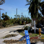
We are currently nearing the beginning the 2022 Hurricane Season. The peak begins mid-August and continues through mid-October, accounting for 78% of the tropical storm days, 87% of the category 1 and 2 hurricane days and a whopping 96% of the major category 3, 4 and 5 hurricane days. The National Hurricane Center has predicted an above-average number of Hurricanes and Tropical Storms for the 2022 Atlantic season.
We strongly encourage all residents, business owner and visitors to have a Hurricane plan. A Hurricane plan is vital for everyone who resides on the island. The plan should include an evacuation procedure and the knowledge that you may not be able to return to Captiva for an extended period of time. The Lee County Emergency Operations Center has developed a series of instructional videos available here, that covers everything from making your plan ahead of a major storm to the recovery process that follows. With quizzes and a printable Certificate of Completion, these videos are a great way to learn from our Emergency Management experts at any time with zero risk.
The Fire District works in a Unified Command System and is one of ten disaster response geographic zones located in Lee County. Captiva is in the Sanibel/Captiva geographic zone. Agencies in this zone include; Captiva Island Fire Control District, Sanibel Fire and Rescue District, Lee County Emergency Management, Lee County Sheriff’s Department, City of Sanibel, Sanibel Police Department, Island Water Association, and Lee County Electric Cooperative. All of these agencies work within the unified command system with the Fire Chiefs, Public Safety Chief Officers as the Incident Commanders (IC’s). The IC’s work closely with Lee County Emergency Management to determine the need for evacuations, search/rescue and recovery.
Please stay posted to frequent updates on this website in the event a storm is approaching the southwest Florida coast. Also, please contact the Fire District if you need assistance or have questions in regards to your Hurricane Plan.