Hurricane Milton Update 13
Current Location: 26.7N, 83.5W
Geographic Reference: 70 miles SW of Sarasota, FL
Movement: Northeast at 13 mph
Max Winds: 120 mph gusting to 145 mph
Current Hurricane Severity Index: 23 out of a possible 50 points (11 size, 12 intensity)
Max Predicted Hurricane Severity Index: 23 out of a possible 50 points (11 size, 12 intensity)
Current Radius of Tropical Storm-Force Winds: 150 miles
Max Predicted Radius of Tropical Storm-Force Winds: 295 miles
Organizational Trend: Decreasing Rapidly
Forecast Confidence: Average
Estimated Central Pressure: 947 mb
Key Points
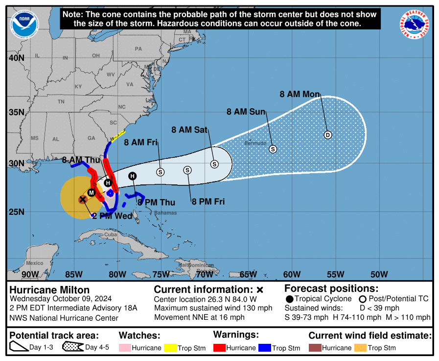
- Hurricane Milton has continued to weaken. Winds are generously estimated at 120 mph. Additional weakening is expected as Milton approaches Florida. At landfall, Milton is now forecast to be a marginal Category 3 hurricane with winds of 115 mph. There is a chance it could be a little weaker.
- Hurricane Milton is expected to strike the west coast of Florida near Sarasota between 9 and 10 PM EDT. Changes to the eventual track can be expected, it is important not to focus on single model runs or solutions!
- It is likely that the strongest winds will remain over the water and not spread over land. However, gusts over 100 mph are expected over the west coast of Florida near where Hurricane Milton makes landfall.
- A tornado outbreak is underway within the rainbands to the east of the center. Numerous confirmed tornadoes have already been reported over the southern part of Florida. Many additional tornadoes are expected today and into tonight.
- Winds coupled with tornadoes will cause widespread and long-lasting power outages as well as moderate to major damage.
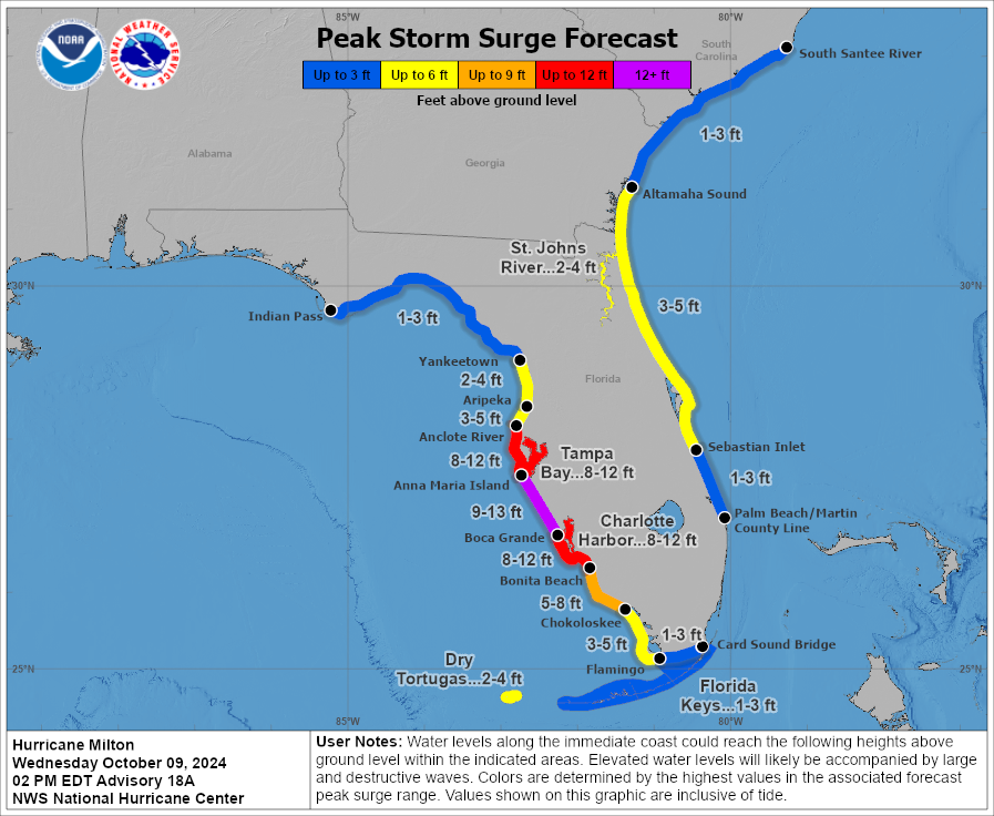
- While Hurricane Milton has weakened, it is starting to grow larger. This is enhancing the storm surge threat, which continues to remain the greatest risk from Hurricane Milton.
Captiva Island Information
- A Flood Watch is in effect for Lee County until Thursday, October 10, 2024.
- Rainfall amounts from the storm are expected to be 4-8 inches for Sanibel and Captiva Island on Wednesday and into Thursday morning.
- Possible storm surge has increased to 10-13 feet . Storm surge is possible on Wednesday as the center nears the coast of Florida to the north. Major coastal flooding and some damage is expected.
- Residents and visitors should evacuate Captiva Island immediately!
- Captiva Island Fire Control District will evacuate today, Wednesday, October 9, as winds increase. Fire personnel will station off island overnight until winds and surge reduce to a safe level. Once that happens personnel will work to access the island and start search and rescue efforts.
- Residents and visitors that own a Lithium-Ion electric vehicles including cars, golf carts, etc. are encouraged to complete an information form on the website. This will allow fire personnel to approach the location with caution and also react accordingly if there is a fire. Please complete the form here.
Lee County Information
- The Emergency Operation Center fully activated as Level 1 on Monday.
- Lee County has issued MANDATORY EVACUATION ORDERS for Zones A & B beginning noon on Monday. Residents should leave before Tuesday evening and find a safe place to stay.
- All Lee County tolls have been suspended.
- Curfews for Lee County are for Sanibel Island and Fort Myers Beach. The curfew started last night at 10 pm.
- Lee County has declared a local state of emergency.
- County offices are now closed and will remain closed through Thursday.
- Lee County Schools are now closed and will remain closed through Friday.
- Shelter locations opened Monday at 3:00 pm and will remain open until further notice. Those locations can be found here.
- Garbage pick-up has suspended operations through the end of the week.
- Lee County Utilities will shut off water to Fort Myers Beach at noon on Tuesday, Oct. 8. This is a precautionary measure to protect infrastructure. All other Lee County Utilities operations continue as normal.